
Keyword
POSBEMED project
11 record(s)
Type of resources
Available actions
Topics
Keywords
Contact for the resource
Provided by
Years
Formats
Representation types
Update frequencies
Status
Scale
panaceaKeywords
GEMET keywords
-
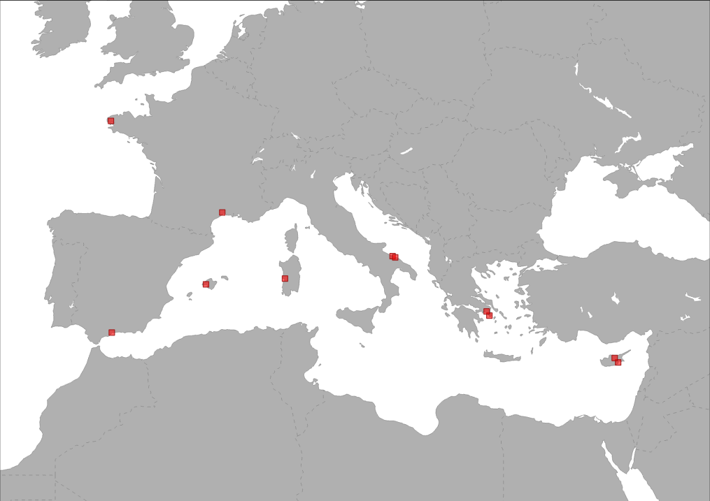
The layer shows type and location of partners involved in POSBEMED project. POSBEMED is a Study Project of the biodiversity protection community funded by the Interreg Med Programme. The POSBEMED project deals with “Sustainable management of the systems Posidonia-beaches in the Mediterranean region”.
-
.PNG)
This dataset contains vector data (point) showing the locations of Posidonia oceanica banquettes along the Northern Mediterranean coasts and is composed of different subsets of point occurence data. The dataset was compiled by the Hellenic Centre for Marine Research (HCMR, Institute of Oceanography) in collaboration with the partners of the project "POSBEMED: Sustainable management of the systems Posidonia-beaches in the Mediterranean region". Data collection from Spain, Italy, Greece, Cyprus, and France was based both on tailor-made field and desktop surveys that contacted through a series of questionaires targeting on several target groups. For Spain, Italy, Greece, Cyprus, Croatia, and Malta several locations of Posidonia banquettes digitized on Google Earth. Coverage is the territory of the following EU countries: Spain, France, Italy, Croatia, Greece, Malta, and Cyprus. The dataset collected for the purposes of POSBEMED project should not be considered as exhaustive and its careful use is recommended.
-
.PNG)
This dataset represents a data compilation of coastal sand dunes distibution along the Northern coasts of Mediterranean Sea. The dataset was compiled by the Hellenic Centre for Marine Research (HCMR, Institute of Oceanography) in collaboration with the partners of the project "POSBEMED: Sustainable management of the systems Posidonia-beaches in the Mediterranean region". Coverage is the territory of the following EU countries: Spain, France, Italy, Croatia, Greece, Malta, and Cyprus. The dataset produced for the purposes of POSBEMED project is not exhaustive, and its careful use is recommended.
-
.PNG)
This dataset shows where potential interactions of "Posidonia-Banquettes-Dunes" system and coastal/touristic activities exist within 12 selected focus areas along the Northern coasts of Mediterranean Sea. This dataset was compiled by the Hellenic Centre for Marine Research (HCMR, Institute of Oceanography) in collaboration with the partners of the project "POSBEMED: Sustainable management of the systems Posidonia-beaches in the Mediterranean region". The areas with potential conflicts (= red polygons) or without conflicts (= green polygons) locating within the focus area are depicted using the EEA Reference grid of 1x1km.The identification of the areas with potential conflicts was based on an overlay analysis using the following thematic layers: Posidonia beds distribution, presence of Posidonia banquettes, presence of coastal dunes, and presence of coastal/touristic activities produced for the purposes of the POSBEMED project.Coverage is the territory of the following EU countries: Spain, France, Italy, Croatia, Greece, Malta, and Cyprus. The dataset produced for the purposes of POSBEMED project is not exhaustive, and its careful use is recommended.
-
.PNG)
This dataset represents locations and boundaries of MPAs (National MPAs and Natura 2000 sites) along the Northern coasts of Mediterranean Sea. This dataset has been created based on the respective product of MAPAMED (Marine Protected Areas in the Mediterranean) GIS database that gathers information on marine protected areas of the Mediterranean, and more generally on sites of interest to the conservation of the marine environment (url: http://www.mapamed.org). It is developed and jointly administered by the MedPAN association and RAC / SPA. (http://www.mapamed.org). Coverage is the territory of the following EU countries: Spain, France, Italy, Croatia, Greece, Malta, and Cyprus.
-
POSBEMED is a Study Project of the biodiversity protection community funded by the Interreg Med Programme. The POSBEMED project deals with "Sustainable management of the systems Posidonia-beaches in the Mediterranean region". The POSBEMED project is addressing topics as GIS database on posidonia meadows, touristic activities and Pas, guidelines for sustainable beach and stranded seagrass management, strategy and action plan for Mediterranean regions and Benchmarking study on management practices for posidonia banquettes/beaches are addressed. This specific map represents the municipalities distribution where the questionnaire on the perceptions about Posidonia banquettes on Mediterranean beaches has been realized.
-
.PNG)
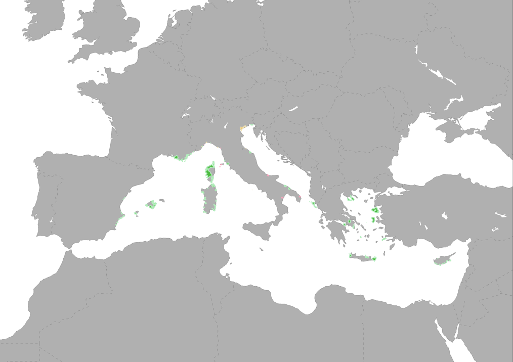
This dataset represents a data compilation of Posidonia oceanica meadows distribution along the Northern coasts of Mediterranean Sea and is composed of different subsets of point and polygon occurence data. The dataset was compiled by the Hellenic Centre for Marine Research (HCMR, Institute of Oceanography) in collaboration with the partners of the project "POSBEMED: Sustainable management of the systems Posidonia-beaches in the Mediterranean region". This dataset shows the distribution of Posidonia meadows in the spatial scale of EEA reference grid 1km. Coverage is the territory of the following EU countries: Spain, France, Italy, Croatia, Greece, Malta, and Cyprus. The dataset produced for the purposes of POSBEMED project is not exhaustive, and its careful use is recommended.
-
.PNG)
This dataset represents a data compilation of coastal/commercial/touristic activities locations along the Northern coasts of Mediterranean Sea and is composed of different subsets of point occurence data. The dataset was compiled by the Hellenic Centre for Marine Research (HCMR, Institute of Oceanography) in collaboration with the partners of the project "POSBEMED: Sustainable management of the systems Posidonia-beaches in the Mediterranean region". Coverage is the territory of the following EU countries: Spain, France, Italy, Croatia, Greece, Malta, and Cyprus. The dataset produced for the purposes of POSBEMED project is not exhaustive, and its careful use is recommended.
-
This video, produced by the project POSBEMED, highlights the value of Posidonia oceanica for the Mediterranean. The POSBEMED project in one of the 9 thematic initiatives under the umbrella of the EU Interreg Med PANACeA project on Biodiversity Protection. POSBEMED is led by the Entente Interdépartementale de Démoustication Méditerranée (EID-Med, Montpellier) in France and involves partners from three more Mediterranean countries: the International Union for Conservation of Nature - Centre for Mediterranean Cooperation (IUCN, Malaga, Spain), the International Marine Centre Foundation (IMC, Sardinia, Italy), ECO-logica srl (Bari, Italy) and the Hellenic Centre for Marine Research (HCMR, Anavissos, Greece). Other associated partners are the Hellenic Society for the Protection of Nature (Greece), Ministry of Agriculture, Rural Development and Environment (Cyprus), Larnaka Municipality (Cyprus), Regional Government of the Balearic Islands (Spain), French Agency for Biodiversity (France), and the Municipality of Giovinazzo (Italy). POSBEMED is an Interreg-Med project co-financed by the European Regional Development Fund.
-
.PNG)
This map shows the geographical location of protected areas involved in the Interreg MED Biodiversity Protection community of projects (period 2019-2022): MPA Engage, MPA NETWORKS, POSBEMED2 and TUNE UP.